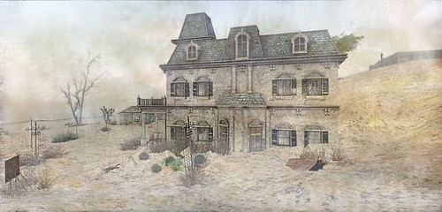
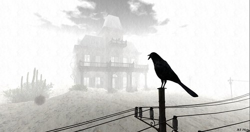
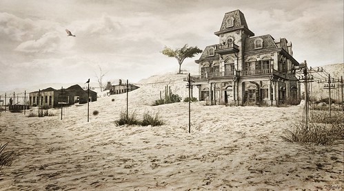
Ojuela is one of Mexico’s ‘ghost towns’, the site of a mine that was abandoned after being decimated by flooding in 1932. It is the subject of our latest sim, which opens today. The landmark is here.
The Ojuela mining settlement is located northwest of the nearest town Mapimí, 5 kilometres (3.1 mi) northwest.
The Ojuela mine was established after the discovery of abandoned gold and silver mines in the area in 1598, and reached its peak during the 19th century, when the extracted ore was transported by railroad to be processed in the nearby town of Mapimí.
Today Ojuela is best known for the “Puente de Ojuela”, which consists of a long pedestrian walkway suspended by a spider’s web of steel cables over a gorge 100 metres below. Completed in 1898, the bridge has a main span of 271.5 metres and the distance between the pylons that support the cables is 315.5 metres. Here is a passage about the early history and purpose of the bridge in a paper by Cristina Matouk Núñez:
“In 1898 … construction of suspended bridge Ojuela concludes, whose main purpose was to facilitate the transfer of the mineral extracted by the Campo Sur shaft towards Ojuela. These fields are separated by a canyon more than 100 meters deep. The bridge [is] still standing, measuring 318 meters in length in a single span, 1.75 m wide and has a suspended weighing over 112 tons. The work [was] made possible the replacement of the burden of animal power to lower ore by the barrel and travel several kilometres around a hill, by an efficient and inexpensive way to load trucks … on a central rail bridge.”
The bridge was designed by Wilhelm Hildenbrand and built by the firm of John A. Roebling Sons Company, New York. Hildenbrand was chief engineer at the firm, while Roebling himself was famous for designing Brooklyn Bridge along with his son, Washington. When the bridge was recently restored, the original wooden pylons were replaced by the steel ones we have modelled at the sim.
Ojuela bridge opened as a tourist attraction in 1991, along with the mining settlement itself. The settlement was originally quite large, with houses clustered in neat rows on the hill to one side of the bridge
Today, only traces of that settlement remain.
As ever, we’ve tried to remain faithful to the ‘real’ Ojuela in our reproduction while bearing mind the need to develop a coherent design within the limits of a Second Life homestead sim. You’ll find some of the old houses (presumably these were mainly homes for miners and administrative offices), the bridge itself, and the dramatic mountainous landscape in which it sits.
We were particularly conscious of scale and hope that we’ve been able to represent just how spectacular this location must be for its visitors – and how scary that bridge walk must be for anyone who suffers from vertigo!
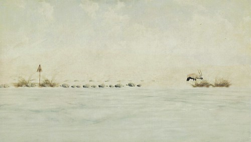
You’ll find a variety of wildlife on the sim which is typical of this area: jaguars, bobcats (aka lynx), a bear and her cub, wolves, lemurs, bighorn sheep, a couple of donkeys and a few rams. Many of these are hidden away, just as they would be in real life. So you’re more likely to hear the wolves than to see them at first, likewise the bears.
There is abundant birdlife, too. You’ll find eagles soaring above (the eagle sits at the centre of the Mexican flag), osprey, kestrels, cuckoos, owls, vultures, red cardinals, orioles, grackles (which is essentially an oversized blackbird), thick-billed parrots (which are endemic to Mexico) …
This was our first brand new sim since North Brother Island, which opened almost three years ago in June 2019. While Jade and I have enjoyed the challenge of designing sims on our own for a while, it was a pleasure to collaborate again, and we hope you enjoy the result. For photographers, the Flickr group is here.
Jade Koltai and I have collaborated on a lot of sims – the first summer version of Furillen, Furillen City, the winter version of Khodovarikha, Black Bayou Lake, two versions of La Digue du Braek and the Isle of May, Rummu, Chesapeake Bay, Ukivok and North Brother Island – and when we discussed working together again recently, we wanted to start by returning to an old favourite, Black Bayou Lake. There’s something we always loved about the atmosphere and light of this sim, but we felt that we could squeeze a little more out of it.
This is exactly what we’ve now done, and version 2 of Black Bayou Lake is now open.
I wrote quite extensively about the real Black Bayou Lake back in October 2018 so I won’t repeat myself here. The most iconic element of that sim, the walkway …
In reality this bridge is located around 100 miles from Black Bayou Lake. It straddles the Twelve Mile Bayou (spelled ‘Twelvemile Bayou’ by locals), which is part of the Cross Bayou, a tributary of the Red River of the South. The bridge was built in 1926 and abandoned during the 1980s. We like the A frame (or upside down V) shape that also makes the walkway so distinctive. This central truss was based on an 1894 patent by John Alexander Low Waddell. It was common throughout the Kansas City, Pittsburg and Gulf and St. Louis Southwestern railroads, and also became a standard feature of crossings along Japan’s Nippon Railway.
When I wrote about Black Bayou Lake last time around, I said that it ‘seethes with life’, and this is even more true of the new version. There are just too many varieties of birds to list – good luck finding them all! – as well as alligators, wild boar and raccoons along with dragonflies. The soundscape echoes all of this. The music stream also fits with the sim’s atmosphere – as does the EEP.
As always, the sim won’t be open forever. Enjoy it while you can, and do please share your pictures in the Flickr group, we love seeing them.
It’s been almost a month, so the time has come to bring the short life of the Dyrhólaey sim to a close – I’ll be turning off the lights at some point over the weekend. I enjoyed designing this sim, and although I was generally pleased with the way it turned out, I somehow doubt that this will be the last time I try to recreate some of the wonderful scenery of Iceland on the grid. Thanks to everyone who visited, posted images in the Flickr group, wrote reviews, or signed the guestbook. You might be pleased to hear that I’ll keep Furillen open for a little while longer, I realise that it’s a bit of a home for some people here.
So what next? All I can say for now is that I’ll be working on something with an old friend …
Iceland is surely on the hit list of every landscape photographer, and it has long been in my thoughts as a potential subject for a Second Life sim. My dream of recreating some Icelandic scenery on the grid has now been realised with Dyrhólaey, which opens today.
In Icelandic, Dyrhólaey – pronounced ‘dir hole ah ay’ – means ‘door hill island’, referring to the arch beneath the cliffs to the east.
My recreation of Dyrhólaey focuses mainly on the promontory itself, but I added a reference to the columns of Reynisdrangar, situated just along the coast. These deep black and oddly gometric basalt formations are among the most visited and photographed tourist hotspots in Iceland.
As with some of the other sims I’ve been involved with – such as the Isle of May, which I designed with Jade Koltai – this ‘reproduction’ is intended mainly to capture the spirit of a place rather than being an exact replica. Of all locations, Iceland is well-nigh impossible to duplicate within the limitatations of Second Life. So while being guided by the overall shape of Dyrhólaey, I’ve taken a few liberties. While Dyrhólaey has its own lighthouse, for example, the one I’ve used at the sim bears a closer resemblance to Skarðsviti Lighthouse, which although situated 350km on the other side of Iceland, is a better fit for the sim. Having said this, both lighthouses are finished in white plaster, with a distinctive red lantern room.
You’ll also find some other interesting buildings on the sim, which I have included as a tribute to some of Iceland’s remarkable architecture. I was especially keen to install a cliffside building – inspired by the ‘cliff retreat’ designed by the ‘architectural visualiser’, Alex Hogrefe. This building doesn’t exist in real life, but the concept is stunning.
There is also a waterfall, which I hope channels the spirit of Svartifoss, which is about 140km along the coast (and a little more inland) to the east. Iceland has many stunning waterfalls, so it would have been remiss of me not to include a scaled-down example here.
You probably won’t be surprised to know that Iceland also has its own specific and unique kind of chickens, known as Íslenska landnámshænan or “Icelandic chicken of the settlers.” As a tribute to these rather handsome creatures, I’ve included a few roosters and hens around the lighthouse keeper’s cottage, although I’ll be the first to admit that mine don’t quite match up to the splendour of the Icelandic variety.
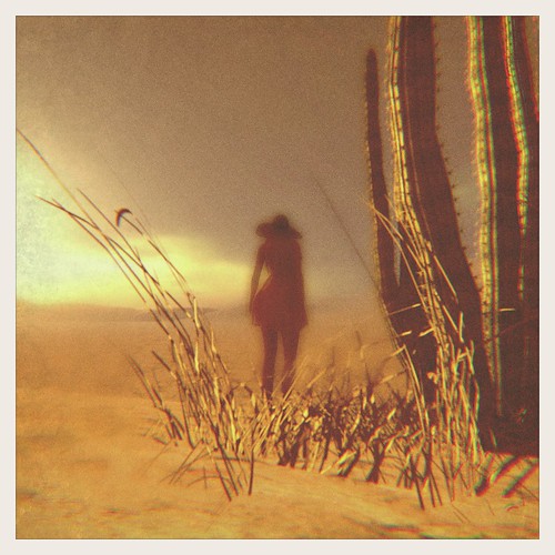
What you won’t find on the sim are trees, simply because there are very few in Iceland. While it’s a myth that Iceland is completely devoid of trees, there do seem to be none at all on the clifftops at Dyrhólaey. This made the landscaping quite a challenge, indeed it’s the first time I’ve designed a sim without being able to dip into my collection of trees. I made up for this by mixing up a variety of wild grasses and flowers which adorn the clifftops and give a nice contrast to the stark black sand below. It’s now spring in Iceland, after all, and believe or not, the Dyrhólaey clifftops are incredibly lush in the warmer months.
You’ll also find some typical wildlife – most notably seals,
and a dolphin swimming and doing tricks in the surrounding sea.
I love being immersed when designing a sim – looking at pictures, watching videos, and trying to make a real place ‘fit’ on the grid. On this occasion I was especially interested in light, which always comes up in accounts of Iceland by those who go there, especially photographers. The ‘default’ EEP setting for the sim is a full day/night cycle, which I hope visitors will switch to using shared environment. If you’re patient, you’ll see the aurora borealis lighting up the skies.
Quite apart from Iceland’s natural wonders, one thing I noticed – and really liked – when researching the sim is the way Icelandic architects utlise artificial light, and I’ve done a little bit of this on the sim. Given the spectacular location of many of Iceland’s most iconic buildings, special lighting renders them quite extraordinary to see and – of course – to photograph. On the sim, the cafe lighting was inspired by the Ion Hotel in Nesjavellir.
Finally, there is one more feature of the sim that I should perhaps explain: the piano on the beach. Here I was inspired by a music video by Hania Rani, the Polish pianist, composer and singer. Athough it was filmed at Vestrahorn more than 250km away, I couldn’t resist the imagery.
Incidentally, the piano used in that video is still there, suitably distressed.
I hope you enjoy visiting this sim. Do catch it while you can, and post your pictures in the Flickr group. As usual, I’ll be closing it in a few short weeks.
[Special thanks to Harry Cover (aka impossibleisnotfrench) for meshing the DC3, and Mara Telling for making the bar in the cliffside building.]
To old friends of the sim, I hope you’ll like seeing the place again. To anyone who has never seen it, do come and visit. It’s unlikely to be open for more than a few weeks, so enjoy it while you can.
For those who might be wondering, I honestly don’t know what I will do next. I usually take a break from SL in the summer months while travelling. But with restrictions on movement unlikely to disappear any time soon, who knows what the summer will bring …
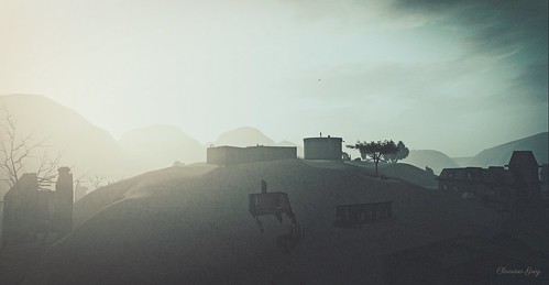
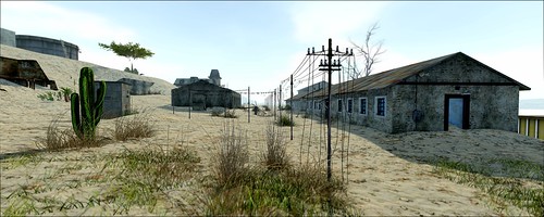
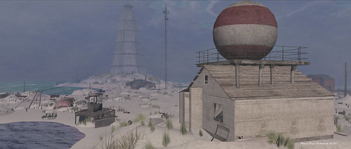
The abandoned ‘ghost town’ of Kolmannskuppe was the site of a diamond mine in the Namib desert that was in operation during the first half of the twentieth century. It is located in southern Namibia, ten kilometres inland from the port town of Lüderitz.
Now a tourist destination operated jointly by De Beers and the Namibian government, Kolmannskuppe is the location of my latest sim, which opens today. The landmark is here.
The name Kolmannskuppe (aka Kolmanskuppe, Kolmanskop & Kolmanskoppe) originated from an ox wagon driver named Johnny Kolman who transported goods from Keetmanshoop to Luderitzbucht in the Namib Desert. He would often make camp in the vicinity of a low-lying gneiss kopje (Kuppe) or hillock, until in 1905 he was caught in a fierce sandstorm, and his oxen vanished. He was fortunately rescued but the wagon remained abandoned for years. From that time the kopje was known as Kolmannskuppe.
In April 1908, Zacharias Lewala, a worker on the railway line between Lüderitz and Aus in what is now southern Namibia, picked up a shiny stone and showed it to his supervisor, August Stauch …
Zacharias Lewala
August Stauch
Recognising the stone immediately, Stauch secured a prospecting license, and within months the diamond rush was on. Kolmannskuppe subsequently became a major site of diamond extraction, producing more than 1,000 kilograms (or five million karats) of diamonds before the First World War.
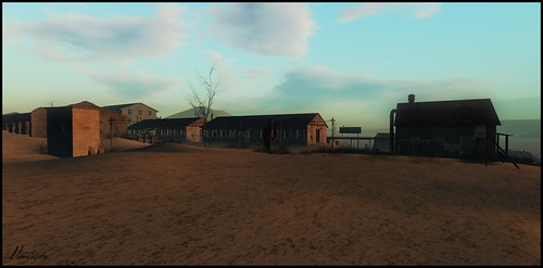
Within a decade or so of Lewala’s discovery, Kolmannskuppe was home to 300 German adults, 40 children and 800 native Owambo contract workers. The town was built in a typical German architectural style, and boasted first-class amenities including a hospital, ballroom, power station, school, bowling alley, theatre, gym, casino, ice factory and the first x-ray-station in the southern hemisphere, as well as the first tram in Africa. Kolmannskuppe also had a railway link to Lüderitz.
OLYMPUS DIGITAL CAMERA
OLYMPUS DIGITAL CAMERA
Kolmannskuppe went into decline after World War II when the diamond-field started to deplete, but its demise had already begun with the discovery – in 1928 – of the richest diamond-bearing deposits ever known, 270 km south of Kolmannskuppe. Many of the town’s inhabitants had headed south, leaving their homes and possessions behind. Kolmannskuppe was eventually abandoned in 1956.
Kolmannskuppe survives today as a much-photographed tourist destination. What makes it extraordinary – and highly photogenic – is the way the desert has ‘swallowed’ many of the buildings, so that visitors walk through houses knee-deep in sand.
Kolmannskuppe has been used as the backdrop for a number of artistic endeavours. For example, it was the subject of the stunning series of photographs by Neil Krug that were used in the album art for Tame Impala’s The Slow Rush, released in February 2020 …
In addition, there are countless videos and blogs, made mainly by tourists, that give a very detailed impression of the stark and haunting buildings that can be found in this desert ghost town …
While Kolmannskuppe’s empty buildings look and feel as if they have been overwhelmed by the harsh and unyielding geology of the desert, elsewhere in the town there is a definite tourist vibe. The buildings are presented in a more ordered state, cleaned up and prepared in readiness for the daily guided tours. Even those bath tubs that you see littered everywhere seem a little bit contrived, exactly the kind of contrivance one might expect to find in a Second Life sim! So in case you think I made them up, here are some of those baths for real …
Kolmannskuppe, then, is a decidedly corporate ‘ghost town’. In light of this, it is hardly surprising that there is a colonial history here which gets underplayed – in so far as it is acknowledged at all – in the official marketing, and passes by almost unnoticed in blogs about Kolmannskuppe by tourists. To take one of the most glaring examples, next to nothing is known about Zacharias Lewala, who went unrewarded for his initial find and enjoyed no share of the wealth subsequently generated because of it. By contrast, August Stauch went on to become a very wealthy diamond miner. As Zora del Buono remarks in an article in the German news magazine der Spiegel …
Lewala’s name entered history but not much more, the man had nothing of his find, no one paid him for it or showed any kind of gratitude, others made the big business and they made it quick.
Namibia itself was once part of the German Empire; the colony to which it belonged was known as German South West Africa. Between 1904 and 1908, this empire perpetrated a genocide against the Herero and Nama people. German rule ended in 1915 with a defeat by South African forces. In 1920, after the end of World War I, the League of Nationsmandated administration of the colony to South Africa. In the later 20th century, uprisings and demands for political representation by native African political activists seeking independence resulted in the UN assuming direct responsibility over the territory in 1966, but South Africa maintained de facto rule. Namibia did not obtain full independence from South Africa until 1990.
In terms of sim design, the tourist elements of Kolmannskuppe were just as challenging and fun to do as the structures covered in sand, if not more so. I especially enjoyed putting together the small gift shop, with custom-made postcards, posters, and tee shirts for sale, as well as the museum area on the floor above – both can be found in the main ‘Kasino’ building.
There are a few ‘signature’ buildings at Kolmannskuppe, and as usual, I tried to capture and recreate at last some of them, starting with that magnificent Kasino pictured above. This was both the largest building in Kolmannskuppe, and the last to be built – it was completed in 1927. It was the entertainment hub of the town, housing a bowling alley, gym and theatre. As far as I can tell from pictures, the gym and theatre were in the same room, which I have placed on the lowest of three floors …
On the floor above you will find a cafe and gift shop, together with the German-style, nine-pin bowling alley, which in real life looks like this …
On the top floor, I have placed the museum, together with a slide show of photographs taken at the real Kolmannskuppe.
Directly opposite the Kasino, you will find the teacher’s house, for which I have utilised the prefab brilliantly created by Marie Lauridsen (aka Milk Motion). This building has those richly coloured walls one finds in so many photographs of the real Kolmannskuppe.
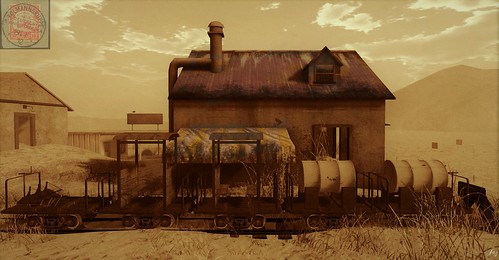
There is another building I wanted to recreate, whose original function I am unsure about. It’s this one ..
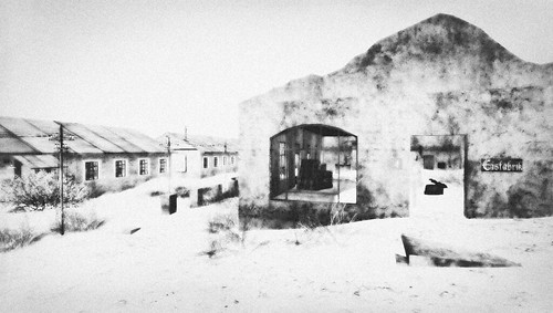
As with my last two sims, I asked Harry Cover to help out with this – and, once again, he did a great job. I designated Harry’s building the ice factory – Eisfabrik. Here the ice was made that the town’s inhabitants used in their fridges. Such a building definitely existed in the old Kolmannskuppe, and you can see its remains today – although not in this exact building. Here are some photographs from inside …
We did not have refrigerators but cooler chests. I remember the ice man doing his rounds delivering ice blocks to the homes from the ice factory. He then put the ice blocks into the cooler chests at every home.
Elsewhere on the sim, I have reproduced the main entrance with its distinct curved walls (and ‘Kolmanskuppe’ spelled with just one ‘n’, a variant I have retained on the tour bus parked next to the Kasino) …
… a distinctive large concrete water storage tank (and the smaller tanks, right next to it) …
… as well as the old hospital, as pictured here …
OLYMPUS DIGITAL CAMERA
There are various other houses, looking much as they do in the real Kolmannskuppe – empty, derelict, and overrun by sand. The two largest houses, situated on either side of the teacher’s house, have a definite ‘colonial’ style.
Somewhat bizarrely, there was a swimming pool in Kolmannskuppe, which I have installed at the sim. This was situated a little distance away on the hill above the town, and I have moved it closer to the remaining buildings. In essence, the pool just consisted of a large and rather deep area surrounded by thick concrete walls …
We had a seawater swimming pool. The water was pumped all the way from Elizabeth bay. It was just a square dam of even depth of two meters. Across this pool we had ropes strung where people could hold on to. The overflow water was used on the plant and for cleaning purposes. There were bathing huts around the pool, birthday parties were held there, and on Sundays, weather permitting, the band played and we all had a jolly time. Although the swimming pool was soon half filled with sand after closure of the town, you could still see the beautiful Italian Terrazzo tiles.
Water was inevitably a major concern for townspeople, and it further explains one other odd feature of Kolmannskuppe, namely its tram.
I had seen pictures of this tram, and managed to recreate it on the sim in a collaborative effort with Harry Cover, who helped with the tram’s seats and brakes. Those barrel-like things at the back were for carrying water, and this was the tram’s main function – to transport water from one end of the town to the other. Harry also helped out by meshing the quirky little diamond retrieval machine that sits next to the Kasino building …
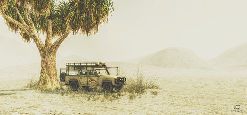
Kolmannskuppe is a desert sim, presenting some challenges in terms of ‘nature’ that I had not tackled before. Besides some rather beautiful desert trees, plants, and cacti, you will find snakes and scorpions, and some animals quite rarely seen on the grid, such as Bighorn sheep, Gemsbock (aka Oryx), Sable Antelope, Wildebeest and Hyenas. Regarding the latter, there is a warning sign right outside the real Kolmanskop (a copy of which I have reproduced at the sim) warning visitors about the threat.
Likewise, you’ll find signs warning tourists to close the doors of houses to prevent snakes from entering, as well as warnings about potential building collapse – and once again, I have replicated these on the sim. As for birds, look out for ravens, vultures, kestrels, osprey, a sandpiper, a great horned owl, and an eagle soaring above.
Like many of you I am now in quarantine, and putting this sim together has been a welcome distraction. As always, I hope that those who visit the sim enjoy what they see, post pictures in the Flickr group, sign the guestbook, and help out with donations.
More than anything, I wish you all good health and serenity. 🙏
Ubay Island opened almost a month ago, so it’s time to close. I’ll be turning out the lights and closing the doors on Wednesday 1st April. Thanks to those who visited the sim and signed the guestbook, posted pictures in the Flickr Group, and wrote generous reviews. These are tough times, and to all those who are affected, and will be affected … solidarity.
No man is an island,
Entire of itself.
Each is a piece of the continent,
A part of the main.
If a clod be washed away by the sea,
Europe is the less.
As well as if a promontory were.
As well as if a manor of thine own
Or of thine friend’s were.
Each man’s death diminishes me,
For I am involved in mankind.
Therefore, send not to know
For whom the bell tolls,
It tolls for thee.
In October 2013, a 7.2-magnitude earthquake struck the province of Bohol, Philippines, causing the land to sink by around 1 metre. Combined with a hundred years’ worth of sea level rise, the earthquake had catastrophic consequences for the islands of Batasan, Pangapasan, Ubay and Bilangbilangan, which have experienced partial or complete flooding ever since. My latest sim project features the smallest of these Islands – Ubay. The landmark is here.
Ubay’s story is as uplifting as it is tragic. Far from being cowed by the rising water levels around them, the islanders simply get on with their daily lives – sometimes waist deep in water.
Ubay Island is tiny. Even without flooding, its land mass would measure just 1.5 hectares. The island is inhabited by a population of little over two hundred people living in fifty households. Of these, roughly three quarters live below the poverty threshold.
I first learned about Ubay Island through a documentary film about all four of the Bohol islands. Called Racing the King Tide, the film focuses on a series of people – teacher, fisherman, mother, auntie, health worker and captain – whose stories and experiences convey just how complex and challenging it must be to live in such conditions …
In reconstructing Ubay I have tried to capture both its spirit and beauty. Although the houses and streets of the island are strewn with floating trash – even the school goes on daily with the children surrounded by it – there is also much that pleases the eye and lifts the spirit, such as the flags that hang over every street, the play areas, the communal spaces, and the surrounding sea with its countless fishing and pleasure boats …
Ubay Island has one ‘signature’ structure, a ruined building in the middle of the sea that’s used as a jumping and diving platform by the island’s children …
Once again, I have relied on the skills of Harry Cover – ‘Impossibleisnotfrench’ – to mesh this structure, and he has done a brilliant job. Harry also made some of the boats you’ll see on the sim, such as the beautiful ‘tourist boat’ on the eastern side …
I’ve also added some touches of my own, such as the graffiti in the submerged basketball court – ‘THIS IS WHERE WE PLAY’ – that one can see in the movie behind the waving boy …
Close by the real Ubay Island – as can be seen in arial photographs – is a swamp area with a solitary building on its edge. My Second Life version of this is a shack that features another aspect of the local culture that may well be unknown to visitors to the sim: Filipino folk magic, known as Kulam or ‘Pagkukulam’.
Putting this sim together has been both humbling and inspiring. Although we cannot know for certain what will become of these islands, it seems likely that they will eventually disappear completely as sea levels continue to rise. Far more permanent, one hopes, is the spirit and resilience of these incredible people. It is in tribute to them that I have created this sim …
As ever, don’t count on the sim staying open for very long. The Flickr group is here. Do please sign the guestbook and feel free to leave a donation! Otherwise, I hope you enjoy your visits. 🙏
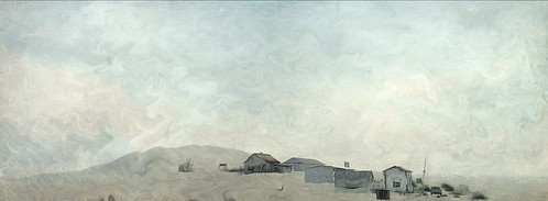
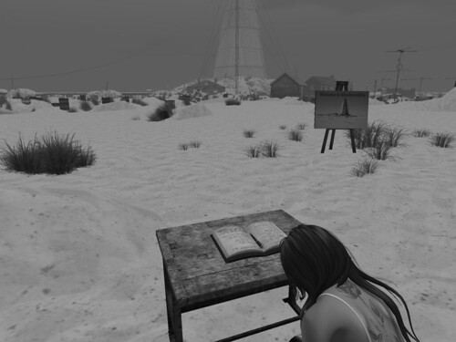
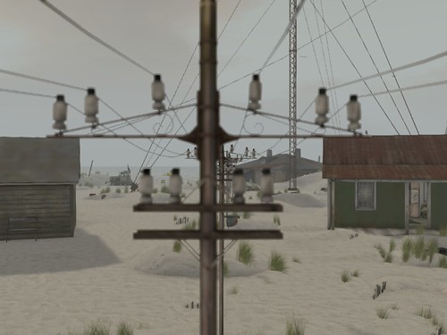
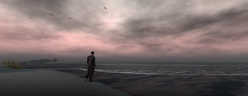
Farewell, Slava! Having opened two weeks ago, the summer version of Khodovarikha will close during the next couple of days. I warned that it wouldn’t stay open for long! This was a version of the sim that I just wanted to get out my system: the main interest for me was in putting it together to see how it would look.
During this brief revival there have been plenty of visitors, some generous reviews, and another few hundred pictures have been added to the Flickr group. Thanks to all who came by, signed the guestbook, and took photographs. Here are some of the highlights …


")

")


![[...art washes away from the soul the dust of everyday life] - Pablo Picasso](https://live.staticflickr.com/65535/49603998716_536e98922e.jpg)


